
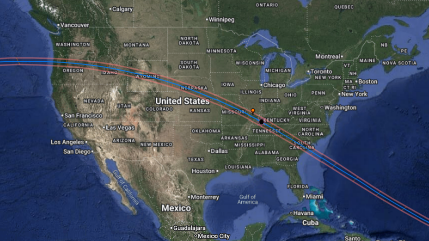
August 21st, 2017 Total Solar Eclipse Map
Impacted Airspace
Clicking the coordinate link will take you to a Google Map with predictions run for August 21st, 2008-2016. Please note that these predictions were ran with the assumption of a ~5m/s rise rate (variable) with Kaymont balloons, a ceiling of 29,000m and a descent profile from Montana balloon flight data.
| ID Number – Description | Launch/GS Site Coordinates | Launch/GS Site Description |
| 001m – KY-BCTC | 37.056033, -88.657765 | West KY Community College/Challenger Center |
| 002m – UKY | 36.797232, -86.815064 | Russellville Airport, Russellville, KY (KY7) |
| 003m – UMaine | 34.6748, -82.8362 | Gallatin, TN |
| 004m – SCSG | 32.457167, -79.342864 | Off South Carolina Coast |
| 005m – NCSG | Tethered System Demo | Tethered System Demo for 008j |
| 006m – USI HAB | 36.759672, -88.138340 | Princeton UK AG Farm, KY5 |
| 008m – Medford HS | 44.46744, -119.53756 | Dayville, Oregon |
| 001j – Temple U | 36.759672, -88.138340 | Kenlake Resort, KY (KY5) |
| 002j – Hooties (OSGC) | 44.726682, -122.179251 | Detroit Lake, Oregon |
| 003j – Wildcat (WSGC) | 44.525, -121.2152 | Culver High School, OR |
| 004j – UWashington | 44.7629759,-121.3795472 | Warm Springs Tribal Lands Warm Springs, Oregon |
| 005j – NASA NE | 40.884902, -98.373556 | Museum – Grand Island, NE |
| 006j – SCC | 34.507315, -82.688893 | Tri-County Technical College – Anderson,SC |
| 007j – LBCC | 44.87, -125.00 | West of Oregon Coast |
| 008j – Lenoir-Rhyne | 35.20376, -82.87823 | Pisgah Astronomical Research Institute Rosman, NC |
| 009j – AR BalloonSat | 38.8723, -91.9402 | Fulton High School, Fulton, MO |
| 010j – MU-SPACE | 37.88529, -89.49277 -OR- 37.65547, -89.50733 | Bower Park, Ava, IL -OR- Power Plant Road, Grand Tower, IL |
| 013j – UHartford /Bridgeport | 36.759672, -88.138340 | KY5 |
| 014j – NMSU | 40.286825, -96.832330 | Homestead National Monument of America, NE |
| 016j – Gannon | ** KY Launch Site ** | KY3 |
| 017j – Alaska SG and Mt. Edgecumbe HS | 44.5646, -123.2620 | Corvallis, OR |
| 018j – ND AESIR | 43.83217,-111.80636 | Rexburg Airport, ID |
| 019j – Sunspots | 44.2624, -116.9789: Ground Station Location, 44.4390, -116.8145: Southerly Drift Launch Site, 44.4455,-117.3319: Easterly Drift, 43.9781,-117.2509: Northerly Drift | Weiser high School, ID |
| 020j – Puerto Rico | 32.790276, -79.961389 | Charleston Riverdogs Stadium, SC |
| 022j – South Dakota | 41.867, -103.5900
(42.683, -103.4055: Backup) |
Scottsbluff, NE
(Crawford, NE: Backup) |
| 023j – Georgia | 34.954194, -82.877943 | Sunset, SC |
| 024j – AZSGC ASCEND | 42.493333, -104.981667 | Glendo Reservoir, WY |
| 025j – Vanderbilt | 36.147703, -86.802238 | Vanderbilt University, TN |
| 026j – BAMA-Sat | 33.49178285, -80.85556157 | South Carolina State University, SC |
| 027j – NevadaSat | ||
| 028j – WY Space Cowboys | 42.965825, -106.366501 | Casper, Wy |
| 029j – Silverton HS – OSGC | 45.0141, -122.7792 | Silverton High School, OR |
| 030j – Portland SU | 44.5646, -123.2620 | Corvallis, OR |
| 031j/002m – KY | 36.797232, -86.815064 | Russellville Airport, Russellville, KY (KY7) |
| 032j – HCC | 36.8827, -87.4863 | Hopkinsville Community College, KY (KY10) |
| 033mj – UMontana | 42.314715, -104.433326 | N or Fort Laramie, WY |
| 034j – UAlabama Huntsville | 36.535526, -87.356213 | Austin Peay State University, TN |
| 036j – Vanderbilt/PSCC | 34.4652, -81.8776 | Clinton, SC |
| 037j – Knox County | 37.073023, -87.663743 | Pennyrile Forest State Resort Park, KY |
| 039j – APSU | 36.561136, -87.341655 | Austin Peay State University, TN |
| 040j – UPittsburgh | 36.594786, -86.915797 | Springfield Church |
| 041j – Wind River | 43.239392, -108.689239 | Pavillion, WY |
| 042j – Culver HS | 44.525, -121.2152 | Culver High School, OR |
| 043j – Muleriders ARSGC | 36.1448, -86.8026 | Nashville, TN |
| 044j – SC Palmetto HS | 33.1946, -80.0021 | Monks Corner Regional Recreation Complex, SC |
| 045j – SC Stall HS | 32.790341,-79.961357 | Charleston Riverdogs Stadium, SC |
| 046j – Tigard HS | 44.525, -121.2152 | Culver High School, OR |
| 001naw – Team Strato MI | 36.408517, -86.434057 | Joe Shafer Middle School, TN |
| 004naw – SSH & RAC | 37.8053, -89.0801 | Colp, IL |
| 005naw – USC | 43.632105, -113.304432 | Bottolfsen Park in Arco, ID with Craters of the Moon National Monument and Preserve |
| 012j – COSGC | 42.054299, -104.938189 | Phifer Airfield, WY |
| 015mj – LaAces LSU | 37.708590, -89.216577 | Southern Illinois University |
| 021mj – UofMinn | 40.884902, -98.373556 | Museum – Grand Island, NE |
| 035mj – MontanaSU MSGC | 43.83217, -111.80636 | Rexburg Airport, ID |
| 007naw – Loki Lego Launcher | 42.472982, -104.956065 | Glendo Reservoir, WY |
** KY Launch Site ** – These teams will be launching from one of the KY predetermined launch location sites below:
| KY Launch/GS Site Coordinates | KY Launch/GS Site Description |
| 37.771907, -87.111168 | Owensboro, KY2 |
| 36.868806, -87.823902 | Trigg County HS, KY3 |
| 37.030960, -85.954085 | Glassgow Airport, Glassgow, KY4 |
| 36.759672, -88.138340 | Kenlake Resort, KY5 |
| 36.797232, -86.815064 | Russellville Airport, Russellville, KY7 |
| 36.742359, -86.219545 | Allen County Scottsville High School – KY8 |
| 36.741723, -88.636715 | Mayfield, KY9 |
| 37.055542, -88.657954 | Paducah, KY9 |
| 36.8827, -87.4863 | Hopkinsville, KY10 |