
Engineering Lesson 5: Weather, Earth's atmosphere, and atmospheric gravity waves
Overview of the content
This lesson offers an introduction to Earth’s atmosphere and meteorology including weather forecasting for balloon flights. You will also learn aboutbasic gravity waves and the process used by the engineering teams to detect them.
Learning objectives
After completing this lesson, students will be able to:
- Understand the concept of the atmospheric boundary layer.
- Be aware of the surface energy balance and how it influences the boundary layer behavior
- Explain the general trends in winds at each layer of the lower atmosphere.
- Understand the possible impacts of the solar eclipse and how these impacts could change depending on different circumstances
- Identify multiple sources of weather information that is appropriate for balloon flight planning.
- Identify weather that can negatively impact ballooning.
- Be able to describe the basic concept of gravity waves
Earth's atmosphere: the atmospheric boundary layer
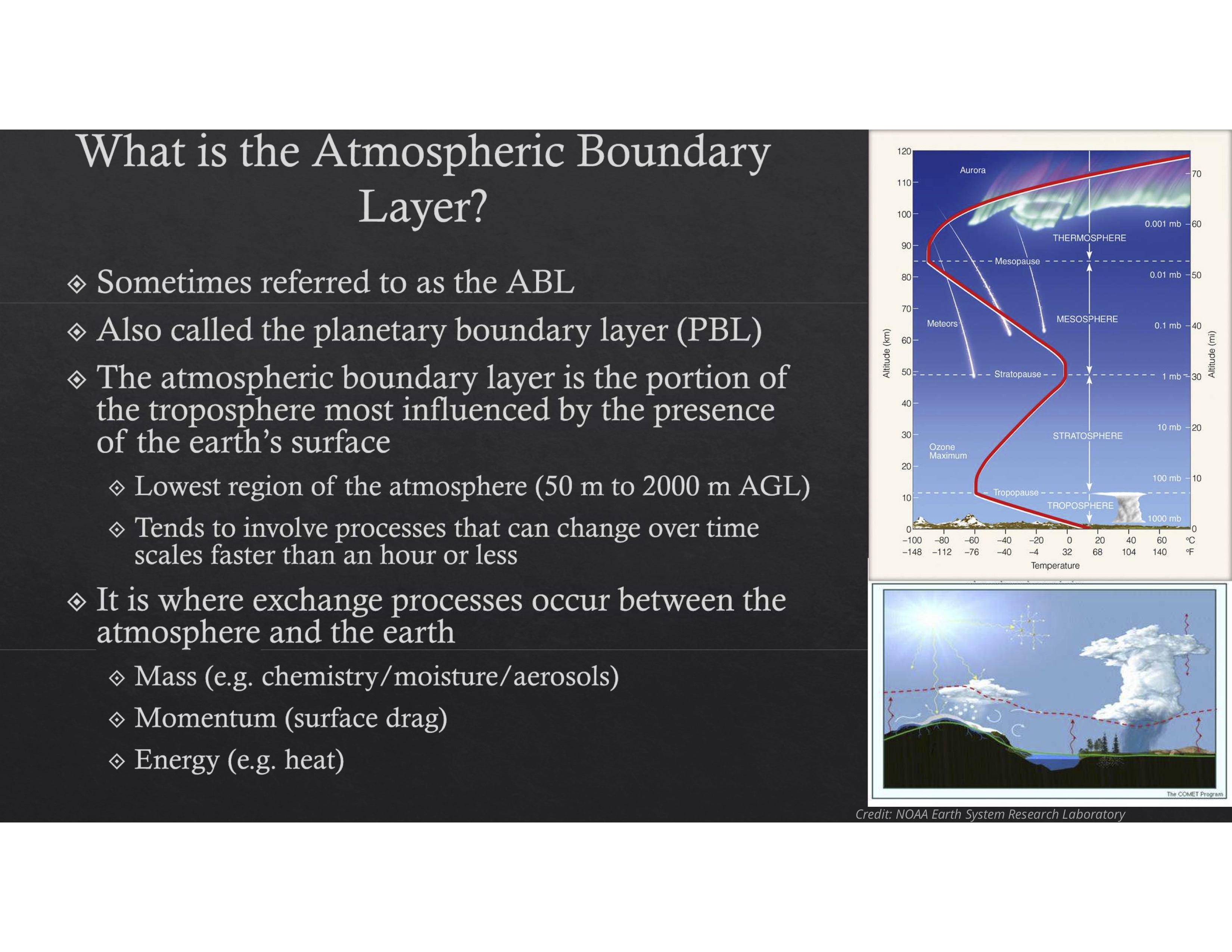
Introduction to the Atmospheric Boundary Layer -- by Dr. Sean Bailey, University of Kentucky [YouTube video, 33 min, Closed Captioned] Learn about the daily cycle of the boundary layer and the possible effects of an eclipse.
Access / download the slide deck for Introduction to the Atmospheric Boundary Layer
Weather Forecasting
It is essential to check the weather forecast and the trajectory predictions while planning a balloon launch
- Launching in high winds can be very difficult and hazardous
- Rain can damage payloads, short out electrical systems, and will add a considerable amount of weight to balloon
- Fog and low overcast will obstruct visibility
Reviewing trajectory predictions will provide the information needed to
- Pick a good launch site
- Avoid restricted airspace
- Predict an approximate landing zone
(You will learn more about how to predict trajectories in Lesson 9)
Weather models
- For weather predictions, use windy.com which shows weather characteristics from different weather models over the next few days for a range of altitudes
- Best models to use are the ECMWF and GFS for long range predictions, and then NAM for near term predictions (just a couple days out)
- By entering a specific location you can view the steady winds, wind gusts, and precipitation at that location based on each model
- When the models agree and when the predictions stay steady for a few days, you can generally have more confidence in their accuracy
- Before a front moves through, it’s very hard to predict what will happen afterwards
European Centre for Medium-Range Weather Forecasts (ECMWF)
- also known as the Euro model
- updates every 12 hours and predicts 10 days out
- this model is generally considered the most accurate
Global Forecast System (GFS) Model
- also known as the American model
- updates every 6 hours and predicts 10 days out
- generally considered slightly less accurate
North American Mesoscale (NAM) Forecast System
- detailed model specifically for North America
- updates twice a day and predicts only 2.5 days out
- considered very accurate for near-term US predictions
- same as above
The combination of these 3 models generally gives a very good picture of the upcoming weather, and this picture gets more and more accurate as launch day approaches
Gravity waves
Video and slide deck
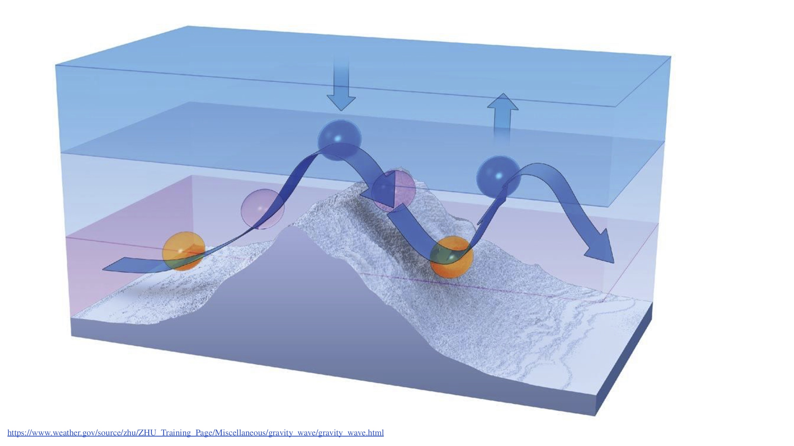
Gravity Waves -- Video by Mary Catlett, Sarah Gordon, Nick Stegmeier, Mystique Fox - Wyoming Space Grant Consortium and South Dakota Space Grant Consortium [YouTube video, 35:10. Closed captioned, transcript available.]
- Gravity waves: View the slide deck for this presentation (same as the video; included as alternate content)
Readings / articles
View the conference poster called Detecting Gravity Saves in the Stratosphere using High Altitude Balloon GPS Data
Gravity Wave Methodology With Explanations and Derivations by Bryce Kim
Extended learning
You may be interested in learning more about gravity waves from the Atmospheric Science perspective.
See Introduction to Atmospheric Gravity Waves
and
![]() Don't forget to track today's progress in your portfolio
Don't forget to track today's progress in your portfolio
Will you take a few minutes to give us some feedback on this lesson? Thank you!
Return to the course home pages
Course home page // Next lesson >>